Easy multi-panel plots in R using facet_wrap() and facet_grid() from ggplot2

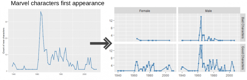
One of the most powerful aspects of the R plotting package ggplot2 is the ease with which you can create multi-panel plots. With a single function you can split a single plot into many related plots using facet_wrap() or facet_grid(). Although creating multi-panel plots with ggplot2 is easy, understanding the difference between methods and some […]

Continue reading →

Using the new R package, FedData, to access federal open datasets (including interactive graphics)

The FedData package (created by R. Kyle Bocinsky) is a great new R package that provides easy access to some important federal datasets. The package is well-designed and provides functions to download climate, elevation, hydrography and other data for your area of interest. The following five sources of data are currently available for download with […]

Continue reading →

Manipulating and mapping US Census data in R using the acs, tigris and leaflet packages

Census data the hard way Plotting census data with ggplot2 Interactive plotting with the leaflet package Options 1: Convert the data.frame back to a SpatialPolygonsDataFrame Options 2: Make use of the existing SpatialPolygonsDataFrame Census data the easy(er) way 1) Set up the packages 2) Get the spatial data (tigris) 3) Get the tabular data (acs) […]

Continue reading →